Up Núpstaðurskógar to Grænalón, over Skeiðarárjökull and back to Skaftafell. Or for google and friends, Up Nupstadurskogar to graenalon, over skeidararjokull and back to skaftafell. Sounded like a great plan. 3-4 days, allegedly one of the most beautiful and remote hiking destinations in Iceland. A perfect walk to showcase Iceland for my two good friends from Australia, Jared and Nerida.
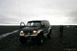
I should have known. Things had just been more difficult than they were meant to, right from the start. The bus we were planning on taking to get into the start (crossing the unfordable river) had stopped running. Last minute dashing and phoning and we managed to find a guy who would drive us into the start for 40,000 kr. Pricey, even by Icelandic standards, but still, a hell of a lot cheaper than 60,000 kr per person per day for the guided trip that every other company I tried to get to drive us in wanted to sell us.
Whatever. We are tough, we are from Australia, and we don't need no stinking guides.
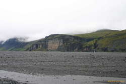
Bjarni from Hörgland was a nice guy though, the head of the Kírkjubærklaustur rescue team, and made for some pleasant conversation as we drove up the sandur, winding our way north towards Núpstaðurskógar, starting from the ring road. Waterfalls and mountain landscapes, big rivers, big sand, the toe of the glacier, fording the Núpsá, and being very glad we paid the money and didn't try and cross it ourselves.
Then, time to start. The rain, which had been threatening all morning started almost as soon as the jeep left. We followed bits of track up to the mouth of the canyon, looking out for the "chain" that we were to take to get up onto the rim of the canyon.
Warm enough weather, rain actually falling straight down, quite unusual for iceland really. Dripping wet trees to brush through, and rain and mist made for some dripping children though.
The chain! We knew the chain was meant to be a little exciting, but finding a chain just hanging down the side of a cliff with some track leading up to it was not exactly what we had in mind. Wet slippery rock, up up and away for about 15m. Quite exciting. Did some gear testing as well, towing packs up the cliff face on the end of the chain.
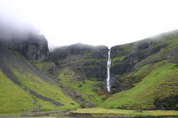
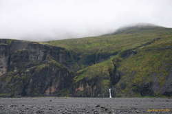
But it was all worth it. Tvílitahylur, the meeting of two rivers, both cascading down beautifully individually into the gorge. One, a blue water mountain stream, one glacial runoff. Absolutely stunning. A magic destination, and one I couldn't believe I'd not see on more postcards and photobooks.
From there we continued heading north, trying to avoid the river canyon on our left, and the craggy peaks of Súlutindur on our right. Very broken terrain, lots of creek canyons cutting through the plateaus, ridge lines going in just about every direction, and weather that just got worse and worse.
Late in the day, with fog that had descended until it completely eveloped us, we even broke out the compass to see if we were still walking in the right direction. (We weren't) Being rather wet, cold and miserable by now, (high spirits only keep you warm for about the first 6 hours it seems) we decided that camping and waiting out the weather was a much better option than trying to follow compass bearings in zero visibility.
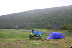
Camp, but where?! The plateaus and hillsides were we traipsing around on weren't exactly the most solid ground. The steady rain, and general oddness of the ground made for squishy muck just about everywhere we looked a bit too sodden to actually erect a tent on. We found a patch of reasonably solid ground eventually, and collapsed into bed. Ate snack food for dinner, no-one wanted to try and cook. Jared and Nerida both got let down by leaking packs and wet sleeping bags. Thankfully some body heat dried them both out by morning.
At this stage, in such miserable weather, and knowing we'd been turned around a bit, we were very seriously wondering how long we'd be out here. Walking back the way we came sounded like a realyl shit option, we wouldn't be able to cross the river, and would have to find our way out down the sandur for 25km, and being unsure of exactly where we were, in miserable weather, our plan was simply to camp out and sleep and rest until the weather got better, and then reeavaluate.
Kendal mint cake.